


Desert Déjà Vu: The Southwest
- Aaron Schorr
- Jan 29, 2021
- 18 min read
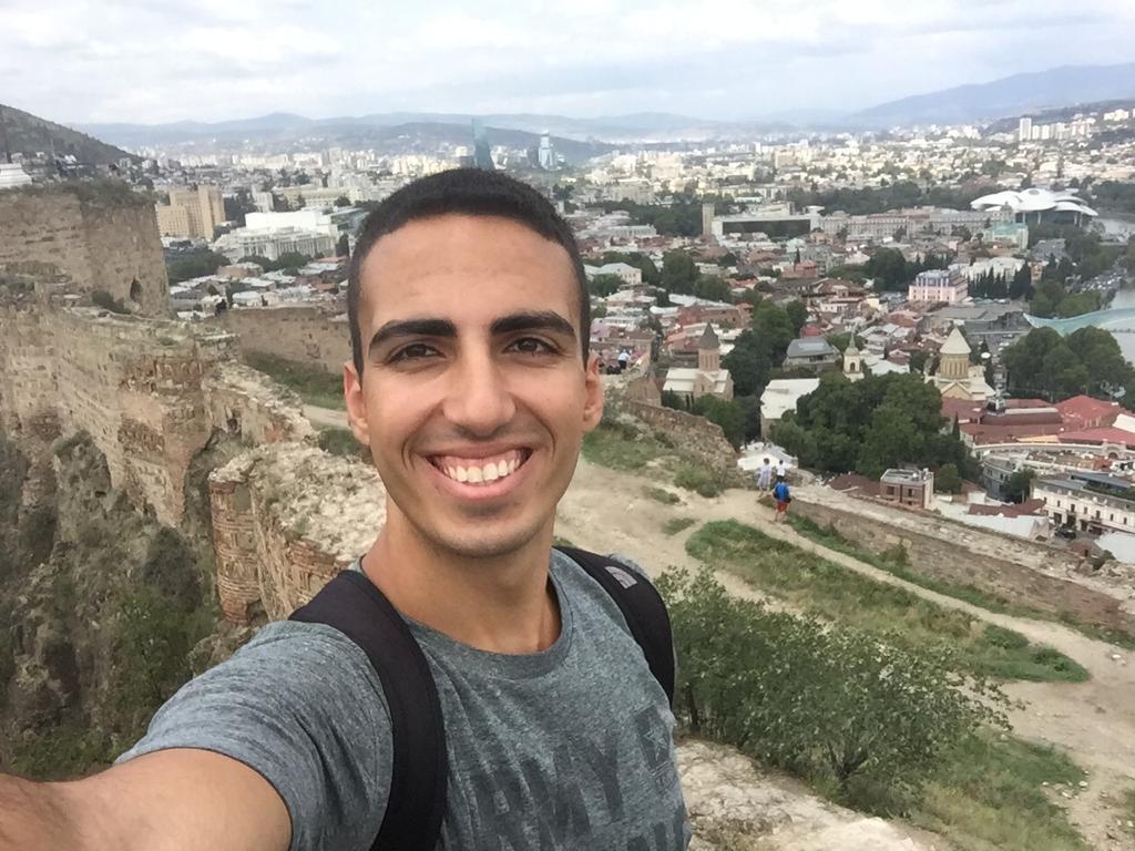
I woke up at 7 to teach Hebrew, only to find out that Hebrew school was cancelled because of MLK Day. Having nothing better to do, I took the car to the supercharger so we could get a head start. The others woke up and we went to a Mexican restaurant (of course) for breakfast, where the waiter immediately started speaking to us in Spanish. The three of us were all conversational in Spanish, so we were doing well until Richard burst the bubble by asking “como se dice ‘over easy’?” It was all English from that point.
We crossed into New Mexico and visited a fireworks shop, which must have had enough explosives in it to flatten the mountains around El Paso. Armed with something mysterious named “YIKES!” and a handful of smaller toys, we left the highway and headed west on a state route. The transition to empty desert was instantaneous, the road stretching into the distance as far as the eye could see. After a few miles the border fence appeared once more, a dark streak snaking up and down the hilly terrain in a perfectly straight line. We wanted to get closer, but there didn’t seem to be any access roads and the area between us and it was a fenced-off cattle ranch. We continued through beautiful, serene desert, occasionally passing Border Patrol vehicles, until we finally spotted a construction path heading south.

Half a mile of uneven gravel later, we were suddenly there, the fence looming above us and blocking our path. The fence is made of metal bars roughly 3 inches wide and 6 deep, rising 30-40 feet above the desert and topped with razor wire. They were, as Jake confirmed, utterly unclimbable. Unlike in El Paso, the Mexican side is just empty desert at this point. We got out and took pictures as quickly as we could, comforted by the knowledge that if anyone tried to join us we would see their dust cloud from far away.


No clouds were spotted and we got back on the main road, undisturbed by anyone on either side of the border. 30 more scenic miles brought us to the small town of Columbus, home of Pancho Villa State Park. Mexican revolutionary Pancho Villa invaded the United States here in 1916 but was driven back by the U.S. Army, who then spent the next two years chasing him all around Mexico in an unsuccessful attempt to capture him. The state park commemorates these events, but was unfortunately closed and the nearby museum was only open to New Mexico residents. We had to console ourselves with a view from a former Army watchtower over the dilapidated town and towards the border.

We then set our course north and promptly encountered a Border Patrol roadblock. We were wary of any contact with the authorities in New Mexico, as out-of-state visitors technically were supposed to quarantine upon entering the state. The agent at the roadblock only wanted to know if everyone in the car was a U.S. citizen, and we were allowed to continue to the town of Deming, where the beautiful desert scenery was in stark contrast with the shabby town. We stopped to charge, got bandanas to complete our desert bandito look, and tried to feed some nearby cows gas station donuts, but they weren’t interested.

The Tale of the Fake Cowboy and the Adobe Historian

We rejoined the interstate and continued to the town of Lordsburg. Perched on a hill a couple miles out of town was a ghost town that was recommended online. Standing at the gate, a man gave the Tesla a funny look but asked us if we wanted to join the tour that was about to start. With a Stetson, goatee, and massive revolver on a leather belt, the man initially looked the part of a guide in an obscure New Mexico attraction, but then I noticed he was wearing sneakers and sported a suspiciously Midwestern accent. My suspicions were confirmed when he said he was from Ohio but had moved out west after marrying the former owner’s daughter.
The ghost town was the former site of a mining town that had sprung up three times between the 1830s and 1920s after different minerals were found in the neighboring hills. It was an interesting look into the past of the Wild West that was such a defining part of the history of this part of the country. The 90,000-pound safe custom-built to house the historical gun collection (photography was unfortunately forbidden) was a bit much, though. We were joined on the tour by a man in his 40s and his daughter. They initally kept to themselves, but as soon as our guide started talking about renovating adobe, the man started peppering him with highly technical and specific questions about the process. As it turned out, he was a historian studying the postwar development of Phoenix who had become an expert in the conservation and renovation of historical buildings in the Southwest.


Dinosaurs, Birds, and Aliens (But No Pie)
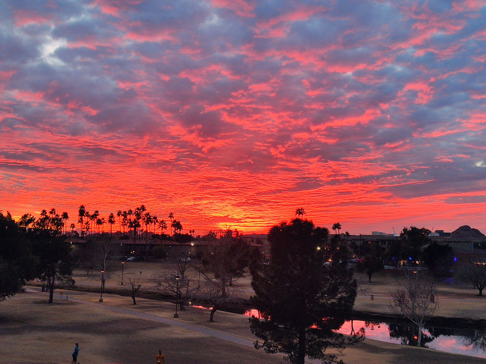
We crossed into Arizona, which was a relief since there were no quarantine restrictions to consider. Admittedly, local license plates had been a minority on the highway in New Mexico, but we still wanted to avoid any problems. We stopped to charge in the town of Willcox, surrounded by flocks of migrating birds that were so big they looked like swarms of locust. There was a pie shop near the charger which looked amazing, but after walking there we discovered it was closed. As a consolation, we were treated to a beautiful desert sunset walking back.


Back at the charging stop in Deming, NM, 150 miles to the east, we had started seeing ads for a roadside attraction called The Thing. I had already heard about it from my online research for the trip, but the sheer volume of roadside advertising was staggering, covering at least 30 billboards on the drive west. We finally arrived at The Thing, paid the $5 entrance fee, and were led into an exhibit behind a gift shop. What followed was roughly 15 minutes of sheer madness, as the creators of the exhibits tried to convince us that a highly advanced alien race had implanted mind control devices in the dinosaurs, prompting them to rebel and their alien overlords to wipe out all life on Earth with a precisely-targeted asteroid. This triggered a civil war between two factions of the alien race, after which the more peace-oriented of the two returned to Earth to nurture the remnants of life there. Evidently, alien guidance was behind every successful empire in history (culminating, of course, in the United States, whose system of government the aliens recognized to be particularly enlightened), until the evil faction showed up and attempted to sabotage this process by supporting enemies of progress, such as the Nazis. In the final chapter, World War II was won by the United States due to its possession of The Thing, an alien artifact of untold power behind many historical events. “The Thing” was actually showcased at the end of the exhibit, looking like a pygmy mummy, after being obtained from the federal government by an unspecified method. I still can't figure out if the place was a joke or not.


A Purgatory Named Tucson
We arrived in Tucson after dark and set out to get dinner. We parked in a garage downtown, when the walls of the building started shaking. We were briefly confused, until a massive freight train passed not 20 feet away from where we were standing. The rest of our evening was no less bizzare. The first place we passed seemed to be a nightclub, with a line of people waiting to enter on the sidewalk and Latin music blasting. A look inside, however, revealed that dancing was prohibited to maintain social distancing, so everyone was just sitting around at tables as their ear drums slowly disintegrated. What a way to spend a Sunday night.
While we were eating dinner on the patio of a Japanese restaurant, a man passed and asked us if the place required masks to enter. We said yes and he simply walked away. Bewildered, we set out to explore the city on electric scooters, but we hadn’t been riding for more than 10 seconds before a random homeless person started swearing at us. We rode to the “historical district”, which was dark, deserted, and did not seem to contain anything of historical value besides an art museum that looked like a bomb shelter. Jake’s phone had died, so he was forced to share a scooter with Richard. They passed by a line of muscle cars; one called them “faggots” as the others jeered, but even this wasn’t the end. Around the corner from where we had set off, we passed two more homeless people, clearly drugged out of their minds, dancing shirtless on the sidewalk in the 55˚ evening air. As far as I’m concerned, if the malevolent alien overlords decide to hit Earth with another asteroid, they should adjust their aim a bit to the north to wipe Tucson out first.
The Excitement of Nuclear War
Leaving Tucson the next morning, we made a slight detour to the south on I-19, the only highway in the U.S. to use kilometers. The unusual choice was made to try and attract more tourists from Mexico to drive up into Arizona, but since the highway ends in Tucson they might as well just stay home (or is it a deliberate plot?). Our reason for driving south was to visit the Titan Missile Museum, 20 miles from Tucson.
At the height of the Cold War, the U.S. Air Force chose the desert of southern Arizona as one of three sites to base nuclear ICBMs directed at the Soviet Union. The site was chosen for its remoteness, but this was the 1960s, right around the time air conditioning had started making places like Arizona and Florida a lot more attractive, so several towns sprung up around the 18 silos sprinkled in the desert south of Tucson. We joined a small group and received a guided tour of the last remaining silo complex from a former serviceman who had spent 3 years in silos such as this one. It was remarkable how well-preserved the silo was 60 years after its construction, sustained by the desert climate and the overkill specifications to which it was built.

Truly, everything about the museum was as remarkable as it was terrifying. If the U.S. detected a nuclear launch in the Soviet Union, Titan II missiles from this silo and 53 others in 3 states could be in the air in under 30 minutes, each ready to deliver a 9 megaton warhead on a major Soviet target. In an age before digital communications and with virtually no computers, that was an incredible feat, horrifying as the prospect of the near-annihilation of the human race in under an hour was. Servicemen who served at these sites, spending 24-hour “alerts” locked into a missile silo and waiting for an order they hoped would never come, would undergo rigorous mental screenings to detect any signs of a nervous breakdown, but our guide made it seem like it was totally normal.


I asked him if there was any moment in his service where he thought to himself “damn, this is completely insane”, and he said there were many, especially during the long nights of boredom and waiting. It was a relief to hear that the people who served here understood the destructive power they wielded and were constantly screened for mental stability, in stark contrast to the man sporting an American flag neck gaiter and a “freedom defender” shirt bearing an M-16 who was with us on the tour and seemed downright excited by the prospect of nuclear war.
We drove north through the desert and passed Pinal Airpark, better known as “the boneyard”. The dry desert climate inhibits corrosion, so airlines store unused aircraft here before they are scrapped, sold, or repurposed. Due to the collapse in demand for air travel, the boneyard is busier than ever, storing aircraft belonging to dozens of airlines across the U.S. The Air Force operates a similar facility across the highway; we tried visiting both but they ironically suspended tours precisely at the moment when they would have been most interesting. Either way, driving past a massive parking lot for commercial aircraft in the middle of the desert was a really strange sight (read this for an idea of what it looks like; taking photos from the highway was impossible).
Back to School (Go Sun Devils?)
Basically all of central Arizona is “greater Phoenix”, an area over 70% larger than the state of Israel (including annexed territories!). The city sits in a vast, featureless plain ringed by distant mountains, so the only thing that differentiates greater Phoenix from empty desert is the pace of the city’s outward expansion, which has skyrocketed over the past 30 years. Another characteristic that defines the metropolis is the use of strange nouns as town names: we saw signs for Globe, Mesa, Surprise, Sunflower, and Strawberry, among others.

Our first destination was the campus of Arizona State University in Tempe, southeast of Phoenix proper. With nearly 43,000 undergraduates and a legendary party scene, ASU is the quintessential “American college” straight out of a Hollywood movie. Trying to blend in, we all put on our backpacks as we toured the campus, which had just reopened for the spring semester. Compared to Yale’s campus, which currently looks like an infectious disease hospital ward, ASU was a breath of fresh air. The architecture is modern and airy and there were tons of people out and about in the sun, with the car’s thermometer showing a record 75˚. We tried as hard as we could to find a class to slip into but had no luck. We eventually did find an open lecture hall to take pictures in, which means I’ve been in more classrooms at ASU than at my own alma mater.

Phoenix has a series of canals that bring drinking water to the city, and several of them have been turned into parks. It was a weekday afternoon, but the park was full of joggers and mountain bikers in a perfect representation of West Coast lifestyle. We climbed a rare hill and got a view of Tempe, Scottsdale, and downtown Phoenix, stumbling upon a homeless person’s belongings in the process. The suburban sprawl continued to the horizon in every direction we turned, but we weren’t even looking at one eighth of the metropolis, which stretches nearly 40 miles further to the west and almost as far to the southeast.

We found a hotel in Scottsdale and checked in with some difficulty, as Jake had made the reservation and they wouldn’t accept a booking from someone under 21. The bureaucracy straightened out, we spent the rest of the afternoon in the pool and hot tub (Arizonans call it a "spa"), which apparently are neither seasonal nor COVID-restricted in this part of the country.
The view from our room was unremarkable, but the desert sunset that evening was even more stunning than usual. We headed to downtown Scottsdale and met Justice, another friend of mine from college and a Scottsdale native. He recommended a fantastic restaurant and gave us the full list of pros and cons of living in Phoenix, which to me sounded horrible. One con he mentioned was the lack of diversity, which suddenly made perfect sense to me. Fully half of greater Phoenix is white, which is one the highest shares in the country, but roughly 30% is Hispanic. Tempe, Scottsdale, and Phoenix, where we had spent the afternoon, are nearly entirely white, while the cities to the northwest are nearly entirely Hispanic. All American cities have a problem with racial segregation, but to see a downtown that was nearly entirely white was strange.
Central Arizona: 3 Seasons in One Day
The next morning we headed back to ASU territory for breakfast. Once again, we were scammed by Tesla, who hid their “free” charger in an exorbitantly expensive parking garage. Richard and Jake both ordered pancakes, which at 1,400 calories a plate were so sweet they were barely edible. Throughout this trip, I was shocked every time anew that restaurant dishes surpassing 1,000 calories were the norm rather than the exception, and not only at fast food restaurants. Any “Southern-style restaurant” was sure to clog your arteries, and with BBQ all bets were off.
We drove east into the mountains on a beautiful road that crossed itself on its way up into the Tonto National Forest. We stopped to charge in Payson, a mountain town 4,000 feet higher than Phoenix. Being nearly at the geographic center of the state, Payson calls itself “The Heart of Arizona”, but all we saw was dreary strip malls and Native Americans in pickup trucks. The temperature was back in the 40s and it was raining, sending us back to the Deep South after the blissful sun in southern Arizona.

On our way down from the mountains, we stopped at Montezuma Castle. Montezuma himself was never actually here; the site is an ancient cave dwelling of the Sinagua people that was repeatedly looted during the 19th century. The site, which was fully viewable from the parking lot, didn’t seem to justify the $10 entrance fee, so we continued onwards.
Arizona Route 179 is considered one of the most beautiful roads in the state, but we initially thought we had been duped once again. Five miles in, the scenery changed almost instantly, the yellow desert with low brush replaced by dramatic red rock formations towering above the town. We stopped to charge, did some wine tasting, and drove out of town to hike. We climbed Cathedral Rock, a commanding red rock formation towering above the town. Considering the temperature in the 40s and the gray skies, there were a surprising number of people on the trail, but the crowds thinned out the further we climbed. The views from the top of the rock were incredible, and every facet we reached revealed a new panoramic vista of the area. I had never been anywhere with this type of scenery before and it looked downright Martian.


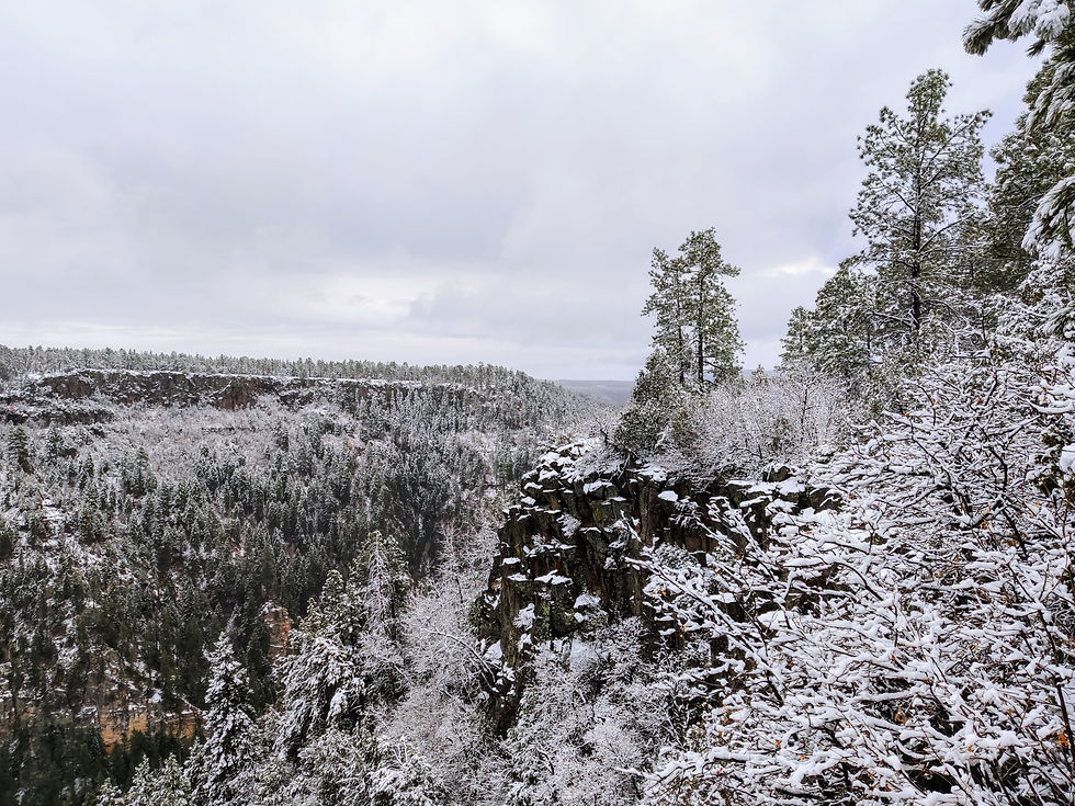
Back in the valley, we continued north through Sedona. For a tourist town, Sedona is surprisingly not garish - the shopping centers are small and reserved, there are no huge billboards, and the buildings are all constructed out of rock in muted shades of red and brown that blend into the surroundings. After navigating more traffic circles than the rest of the trip combined, we drove north up a deep forested gorge created by Oak Creek, which was flowing by the roadside. We increasingly began to see cars covered in snow passing us in the opposite direction, and soon enough we saw why. The road made a series of very dramatic switchbacks to climb out of the canyon, and when we got to the top it was like we were in an entirely different country. The temperature had gradually dropped below freezing as we climbed, and we were surrounded by thick forest, with something like 5 inches of snow covering everything. There was a viewpoint by the road that was closed to cars, but we walked around the gate and laboriously made our way through the snow to get sweeping views of Oak Creek Canyon.

Twenty minutes of driving through the winter wonderland brought us to Flagstaff, where the snow picked up again. The main attraction in town is the Lowell Observatory where Pluto was first discovered, but they were only offering private tours starting at $775 so we couldn’t visit it. There was some contemplation of driving all the way to the Grand Canyon, but the road conditions settled that debate. The roads in town were very icy and the Tesla absolutely was not built to handle driving on ice, so we kept the speed to a minimum and crept through town in search of food. We first got to a pizza place which was only doing takeout, then we tried going to a brewery which wouldn’t seat us since not all of us were 21, and another pizza place was closed. Several unintentional drifts later, we finally found a delicious Thai place which was the perfect way to end this long day. In the 250 miles we had driven since the morning, traveling through four distinct landscapes and losing 43 degrees of temperature in the process.
Red and White in the Grand Canyon
We woke up to find 3 inches of snow and a nasty layer of ice on the car. After scraping everything off and charging, we set off north out of Flagstaff, hoping to travel the scenic route along the South Rim of the Grand Canyon. One of the problems with the Tesla is that when the battery is cold, the car charges extremely slowly, so we were only getting roughly a quarter of the current the charger could provide. The snow didn’t get any shallower as we got closer, and my instincts said we should call the park service and ask whether the road was open. It’s good that we did, because as it turns out the rim road was indeed closed and we likely would have barely had enough battery to go all the way to the gate and drive back to Flagstaff. The u-turn lanes on the road were so heavily snowed over that the car couldn’t go through them, but we eventually found a spot to turn around and return to the dreaded supercharger in Flagstaff, which did much better with our now-warm battery.
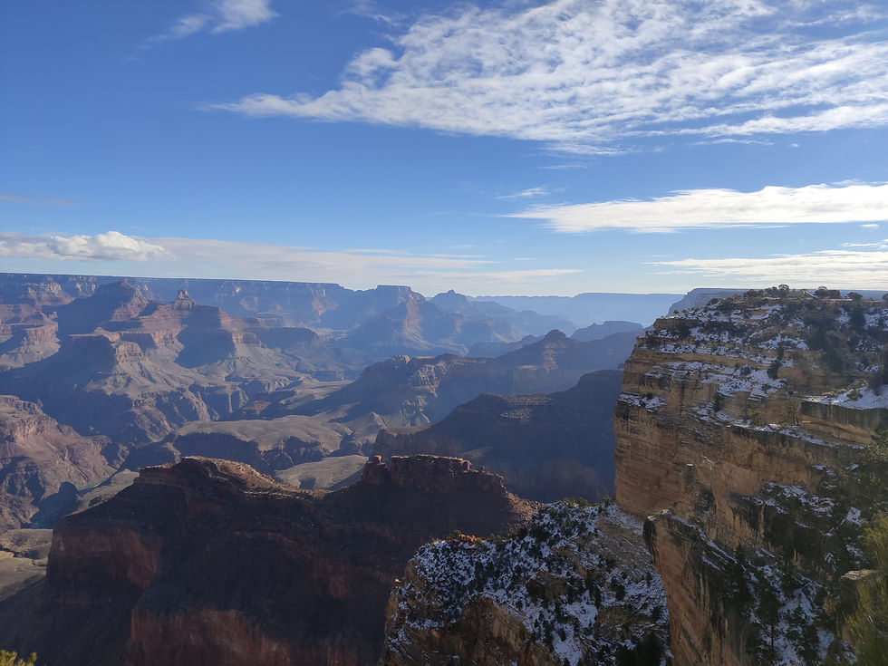
We set off from Flagstaff once more, this time to the west. This was the main route to the Grand Canyon, and it passed through much lower elevation. Within a few miles, the snow was mostly gone and we could cover ground at a reasonable rate again. We listened to Joe Biden’s inauguration as we drove and finally arrived at the national park just before midday, almost two hours after we had planned, and boarded a shuttle bus to take us to the South Kaibab trailhead. This is one of the most-traveled trails in the Grand Canyon, and for good reason. Our first look at the canyon was from the trailhead and it was downright awe-inspiring, layers of stratified rock almost a mile deep in a scale that defied imagination. The upper parts of the trail were quite snowy and our sneakers weren’t quite suited to the task, but we made it down safely beneath the snow line and deeper into the canyon.

Each viewpoint on the way down offered a new angle on the incredible scenery, which showed absolutely no signs of human interference. The skies were sunny enough that it wasn’t too cold, but it not enough to bring crowds onto the trail. The way down is lined with large signs warning not to attempt to go to the river and back in one day and to budget twice as long for the climb as for the descent, so we gave ourselves a turnaround deadline of 2:00 to make sure we were out by sundown. We reached Skeleton Point just before 2:00, which was the highest point on the trail from which the Colorado River was visible. After seeing its sorry state in West Texas, we thought it was a similarly puny stream we spotted at the bottom of the canyon, until Jake went around a rock and found the actual river, which was much more impressive and could even be heard from over a mile away when the wind was blowing in the right direction.
Contrary to the warning signs, the climb back to the rim actually took us less time than the way down, which had contained many more photo breaks. The nearly 3,000 feet of elevation gain, not to mention the elevation of nearly 7,000 feet at the top, made all of our legs scream, but it was well worth it. Triumphant, we made it to the top to the sounds of our victory playlist and ahead of some Princeton kids who had passed us going up over an hour previously.


We took the shuttle bus back to the visitors center and drove out of the park to Tusayan, a village just south of the park gates. Staying here overnight was cheaper than staying in the park, but it still wasn’t cheap. Tusayan wasn’t much of a town, really just half a dozen hotels, a similar number of restaurants, and - blissfully - a Tesla supercharger along the main road. The hotel was comfortable, though, and the Mexican food for dinner was good, and that was all we needed.

Route 66: Kitsch and Looney Tunes Scenery
We were happy to discover that it hadn’t snowed overnight and the car had nothing more than a light dusting of ice on it. We drove back to the park and along Hermit Drive, a highly scenic road along the South Rim that ends at another hiking trail. The morning was slightly hazy, tinging the canyon blue, but the views were still amazing and the river was visible from this point. We briefly started down the trail until we saw its vertical profile and realized we wouldn’t be getting any views without working very hard for them, a task for which our legs were not well-suited.
We left the park and Tusayan a final time, eventually rejoining I-40 heading west. The road signs all said Los Angeles, which still seemed so distant as we hadn’t quite comprehended just how quickly we were running out of country in our dash west. We crossed into the Mojave Desert, which looked different from the Colorado and Sonoran deserts we had been traveling through since Dallas. The terrain was steeper, harsher, and much more barren. Freight trains several miles long thundered past as we made our way west, and I couldn’t quite shake the feeling of déjà vu. For the past several days (the Grand Canyon excluded), I had felt like I had been here before, despite never having seen this type of desert scenery. Suddenly, it hit me: I was traveling through Looney Tunes country. So many hours of watching Road Runner, Bugs Bunny, and Yosemite Sam as a kid had left me with a remarkably accurate impression of the landscapes of the Southwest that really didn’t seem all that new when I finally saw it in person.

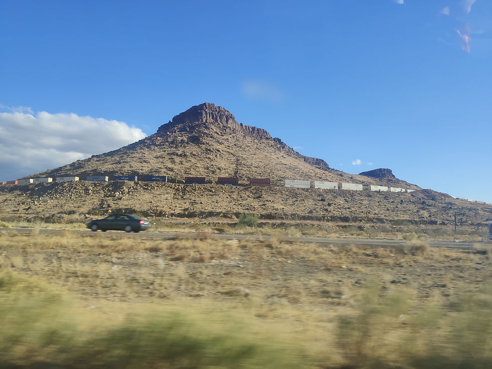
We arrived in the town of Kingman, which had recently enjoyed a brief moment of infamy thanks to an iconic scene from Sasha Baron Cohen’s show Who Is America? Kingman was the epitome of a Route 66 town - dusty desert scenery, motorcycle dealerships (decked out with Confederate flags), 200-car freight trains belching smoke, antique cars on the sidewalks, and lots of pastel-colored diners. We went to Mr D’z Diner, which was both the most pastel-colored and most iconic of them all, with branches in every major town and city along the old highway.
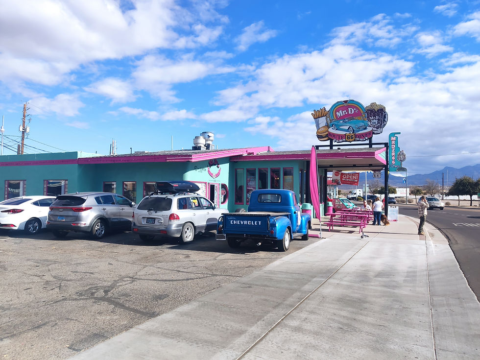
Since the establishment of the Interstate Highway System, Route 66 has become more of an aesthetic than an actual highway, and nowhere is that aesthetic more present than at Mr D’z. From the mid-century road trip decor, through the fonts on the paper menus, to the neon signs outside, everything screamed Western kitsch, even though this was the real deal. The food was classic diner fare but quite good, and I had my first root beer float, which is not that easy to find in 2021.
The real gem of our experience, though, was our waitress. She asked us the usual questions about our road trip and was surprised by how three people from such different locations knew each other, but then launched in to a 20-minute monologue about her life with only minimal prompting from us. She had recently graduated nursing school, but she hated working in nursing homes and her dream was to create “the next fashion empire” by selling clothes online. It was an interesting window into the mind of a type of person I don’t typically meet, and I was enjoying myself until she started telling us about our Zodiac signs and their compatibility with hers. When she started asking us about our “moon energy” I lost track of the conversation entirely, but luckily Richard chose that moment to return with the car he had picked up from the charger.

We still had fireworks we had bought in New Mexico and we were fast approaching the California state line, where fireworks laws are predictably strict. Having missed our opportunities to set them off every preceding night due to cold, being in a city, or fire risk in a national forest, we were faced with the choice of setting them off in daylight or risking setting them off against the law in California. We had both firecrackers and fireworks, so we decided to set off the firecrackers now and hold on to the fireworks. We found a clear and secluded spot behind a rise on a local road and launched everything in quick succession, which was a lot more fun (and loud) than it should have been.


Comentarios